![](/images/other/stat-length.png)
![Tour Zu Fuß The Municipal District of Dungarvan — Lismore - Glenshelane Red Walk - Photo](https://media.geolcdn.com/t/1900/400/bd0dfdaa-1657-4562-a015-69ecb63551b1.jpeg&format=pjpeg&maxdim=2)
Glenshelane Red Walk
SityTrail - itinéraires balisés pédestres
Tous les sentiers balisés d’Europe GUIDE+
![Länge](/images/other/stat-length.png)
Länge
5,3 km
![Maximale Höhe](https://static1.geolcdn.com/siteimages/upload/files/1508320355ic_sort_altitude_max_24dp.png)
Maximale Höhe
142 m
![Positive Höhendifferenz](https://static1.geolcdn.com/siteimages/upload/files/1508320355ic_sort_den_pos_24dp.png)
Positive Höhendifferenz
170 m
![Km-Effort](/images/other/stat-length.png)
Km-Effort
7,3 km
![Min. Höhe](https://static1.geolcdn.com/siteimages/upload/files/1508320355ic_sort_altitude_min_24dp.png)
Min. Höhe
28 m
![Negative Höhendifferenz](https://static1.geolcdn.com/siteimages/upload/files/1508320355ic_sort_den_neg_24dp.png)
Negative Höhendifferenz
77 m
![Boucle](https://static1.geolcdn.com/siteimages/upload/files/16400158638029165_repeat_loop_refresh_sync_direction_icon.png)
Boucle
Nein
Kennzeichnung
Erstellungsdatum :
2025-02-06 12:24:49.867
Letzte Änderung :
2025-02-06 12:24:49.867
![Zu Fuß](https://static1.geolcdn.com/sitytour/trail-icons/100.png)
1h38
Schwierigkeit : Einfach
![Scannen Sie diesen QR-Code, um die Tour in der SityTrail-Anwendung zu öffnen](https://capi.geolives.com/qq0zvz2zws4bq2lad0pu/sitytour/trails/4342839/qr.png?size=200)
Kostenlosegpshiking-Anwendung
Über SityTrail
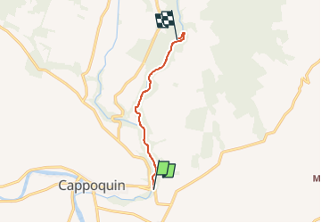
Tour Zu Fuß von 5,3 km verfügbar auf Unbekannt, County Waterford, The Municipal District of Dungarvan — Lismore. Diese Tour wird von SityTrail - itinéraires balisés pédestres vorgeschlagen.
Beschreibung
Tour erstellt von Coillte.
Symbol: red circle
Ort
Land:
Ireland
Region :
Unbekannt
Abteilung/Provinz :
County Waterford
Kommune :
The Municipal District of Dungarvan — Lismore
Standort:
Ballyhane
Gehen Sie:(Dec)
Gehen Sie:(UTM)
580299 ; 5777896 (29U) N.
Kommentare
Touren in der Umgebung
![Tour Wandern The Municipal District of Comeragh - 20100706090743 - Photo](https://media.geolcdn.com/t/375/260/ext.jpg?maxdim=2&url=https%3A%2F%2Fstatic1.geolcdn.com%2Fsiteimages%2Fupload%2Ffiles%2F1553511878bg_sport_marche.png)
![Wandern Wandern](https://static1.geolcdn.com/sitytour/trail-icons/101.png)
20100706090743
Wandern
Sehr leicht
The Municipal District of Comeragh,
Unbekannt,
County Waterford,
Ireland
![](/images/other/stat-length.png)
115 km | 158 km-effort
36h 19min
![](https://static1.geolcdn.com/siteimages/upload/files/16400158638029165_repeat_loop_refresh_sync_direction_icon.png)
Nein
![Tour Wandern The Municipal District of Comeragh - Nire valley - Photo](https://media.geolcdn.com/t/375/260/ext.jpg?maxdim=2&url=https%3A%2F%2Fstatic1.geolcdn.com%2Fsiteimages%2Fupload%2Ffiles%2F1553511878bg_sport_marche.png)
![Wandern Wandern](https://static1.geolcdn.com/sitytour/trail-icons/101.png)
Nire valley
Wandern
Medium
The Municipal District of Comeragh,
Unbekannt,
County Waterford,
Ireland
![](/images/other/stat-length.png)
7,3 km | 11 km-effort
3h 0min
![](https://static1.geolcdn.com/siteimages/upload/files/16400158638029165_repeat_loop_refresh_sync_direction_icon.png)
Ja
![Tour Wandern The Municipal District of Cahir — Cashel - Randoguide - Photo](https://media.geolcdn.com/t/375/260/ext.jpg?maxdim=2&url=https%3A%2F%2Fstatic1.geolcdn.com%2Fsiteimages%2Fupload%2Ffiles%2F1553511878bg_sport_marche.png)
![Wandern Wandern](https://static1.geolcdn.com/sitytour/trail-icons/101.png)
Randoguide
Wandern
Einfach
The Municipal District of Cahir — Cashel,
Unbekannt,
County Tipperary,
Ireland
![](/images/other/stat-length.png)
9,1 km | 12,1 km-effort
Unbekannt
![](https://static1.geolcdn.com/siteimages/upload/files/16400158638029165_repeat_loop_refresh_sync_direction_icon.png)
Ja
![Tour Wandern The Municipal District of Comeragh - Randoguide - Photo](https://media.geolcdn.com/t/375/260/ext.jpg?maxdim=2&url=https%3A%2F%2Fstatic1.geolcdn.com%2Fsiteimages%2Fupload%2Ffiles%2F1553511878bg_sport_marche.png)
![Wandern Wandern](https://static1.geolcdn.com/sitytour/trail-icons/101.png)
Randoguide
Wandern
Schwierig
The Municipal District of Comeragh,
Unbekannt,
County Waterford,
Ireland
![](/images/other/stat-length.png)
22 km | 37 km-effort
Unbekannt
![](https://static1.geolcdn.com/siteimages/upload/files/16400158638029165_repeat_loop_refresh_sync_direction_icon.png)
Nein
![Tour Zu Fuß The Municipal District of East Cork - Youghal Foxhole Loop walk - Photo](https://media.geolcdn.com/t/375/260/d3498ff3-1c4e-471b-96f2-d30dff3ee875.jpeg&format=jpg&maxdim=2)
![Zu Fuß Zu Fuß](https://static1.geolcdn.com/sitytour/trail-icons/100.png)
Youghal Foxhole Loop walk
Zu Fuß
Einfach
The Municipal District of East Cork,
Unbekannt,
County Cork,
Ireland
![](/images/other/stat-length.png)
4,5 km | 4,7 km-effort
1h 3min
![](https://static1.geolcdn.com/siteimages/upload/files/16400158638029165_repeat_loop_refresh_sync_direction_icon.png)
Ja